Canada topo maps free app for android description: Easy to use outdoor navigation app with the best topographic maps of canada.
This app gives you similar mapping options as you might know from garmin or magellan gps handhelds.
Attention: please use toporama or canada base map layer if you need most recent topo maps!
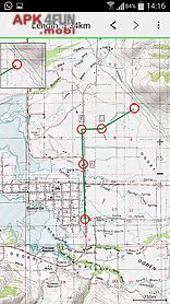
Main features for outdoor navigation: bulk download of map tiles for offline usage (not in this free version) create and edit waypoints goto waypoint navigation create and edit routes route navigation (not in this free version) track recording (with speed elevation and accuracy profile) tripmaster with fields for odometer average speed bearing elevation etc.
Gpx import export kml export search (placenames pois streets) customizable datafields in map view and tripmaster (e.
G.
Speed distance compass...
) Share waypoints tracks or routes (via email facebook..
) Use coordinates in utm wgs84 or mgrs and many more...
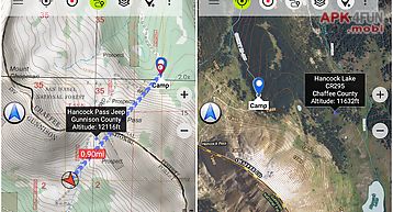
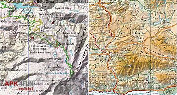
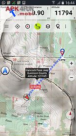
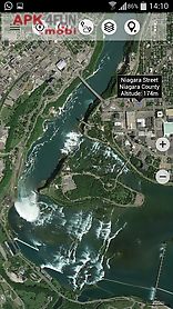
Available map layers: topomaps canada (canmatrix seamless coverage at scales 1: 50.
000 and 1: 250.
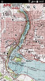
000) toporama maps canada in en fr (canvec ntdb atlas of canada) canada basemap (canvec ntdb atlas of canada) cantopo (new canada topos at 1: 50.
000 partial coverage of can) google maps (satellite images road and terrain map) bing maps (satellite images road map) open street maps (osm mapnik and cloudemade cyclemap) hillshading overlay layer (not in this free version)toporama maps canada: these are the most recent topographic maps of canada.
Topomaps canada: these maps contain many small pathes and 4wd tracks that are missing in toporama google bing and osm maps.
This layer is essential for real outdoor and offroad trips in canada.
Seamless mosaic of more than 1- 000 collar clipped 1: 50.
000 maps.
Limitations of the free version: ads no bulkdownload no hillshading overlay max.
3 waypoints max.
3 tracks no routes no import of waypoints and tracks no local city db (offline search)use t