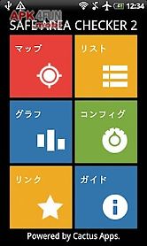
Safeareachecker2 app for android description: the tohoku region pacific ocean coast earthquake.
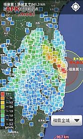
This time i released the app to show current location on a map the distance from the nuclear power plant in fukushima japan.
In addition to on the map shows evacuation radius and the direction of the wind and radiation levels (unit of radiation is micro sv h ).
Information developer cactusapps.
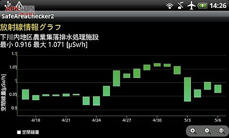
Facebook https: pages cactusapps 279082165486955ver - - 0 : add a function of radiation graph.
Ver - - 0 : speed up the map.
Ver - 0.
0 : radiation corresponds to the site provides information of the ministry of education was revised in april 201- renewal application.
Ver - 0.
0 : add a function to automatically update.
Change the look of graph information.
Ver.
- 1- 0 : add a function of balloon speed switching.
Ver.
- 1- 0 : prepare an emergency evacuation of the area cleared (9 30).
Ver.
- 10.
0 : change the graph of the map.
Ver.
- - 0 : fukushima radiation data change data in the the ministry of education.
Ver.
- - 0 : add a new type of home screen widgets.
To view any of the points.
Ver.
- - 0 : home screen widgets support.
Ver.
- - 0 : added a function of display information in a balloon when you tap a point.
Ver - - 0 : add a function of display information in a graph of radiation in the past.
Ver - - 0 : update planned evacuation zone.
Change information list of radiation.
Add a satellite photo display mode.
Ver - - 0 : add a function to share the current state.
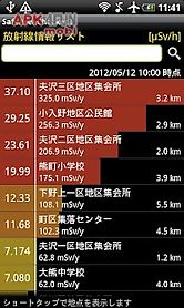
Ver - - 0 : add a function of the bar graph displays the radiation dose on the map.
Ver - - 0 : add a function of view of planned evacuation zone.
Ver - 0.
0 : view point expanded all over the country.
Ver - - 0 : add a function of the list of values of radiation.
Ver - - 0 : add a function of view of predictions speedi.
Ver - - 0 : add a function of view of radiation.
Ver - - 0 : add a function of view of wind direction.
Ver - - 0 : add a function of view of distances from where you tapped.
Ver - 0.
0 : new release.
Notes accuracy of