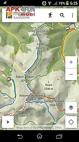
Hiking map poland app for android description: Hiking map poland helps you plan hiking routes and navigate the trail.
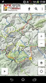
The main functionality is planning routes leading along official hiking trails in the mountains and foothills of poland.
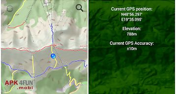
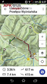
The app finds a route quick and easy displays it on a map shows its length estimated time and detailed course.
It also shows your current location.
In online mode routes are displayed on google maps layer.
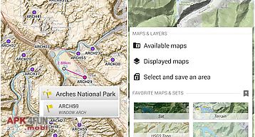
It 39 s also possible to download offline maps.
Moreover it records your trails for later.
It saves the route on the map including the length and elapsed time.
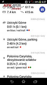
The app also displays information about points of interest: photos and opinions taken from the mapa turystyczna.
Pl website.
Detailed functionalities: setting routes based on given points points can be chosen from map or found using the search box intelligent search suggestions considering spots closest to your location and most popular spots displaying routes on a map along with their length estimated time and route details (spots and trails) showing your current location on the map showing the direction of movement on the map recording trail showing elapsing distance and time recording can be paused list of recorded trails searching for places and showing them on the map displaying information about places your searched for: photos and opinions taken from mapa turystyczna.
Pl website download offline maps layer.
Available trails from regions: karpaty (carpathians): beskid slaski beskid zywiecki bieszczady pieniny tatry (tatra mountains) beskid makowski beskid maly beskid niski beskid sadecki beskid wyspowy gorce jura krakowsko cz stochowska podhale pog rze ciezkowickie pog rze przemyskie pog rze roznowskie pog rze strzyzowsko dynowskie pog rze wielickie pog rze wisnickie sudety (sudeten): karkonosze g ry stolowe (table mountains) g ry bardzkie g ry bystrzyckie i orlickie g ry izerskie g ry kacz