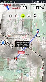
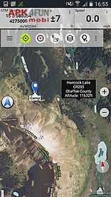
Us topo maps free app for android description: Easy to use outdoor navigation app with free access to the best topographic maps and aerial images for the usa.
Please use usgs national map or osm if you need most recent maps choose between 20 map layers (topos aerials sea charts flight charts...
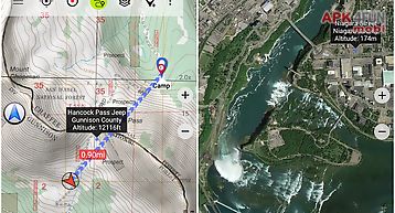
)Turn your andoid phone tablet into an outdoor gps for trips into the backcountry.
This app gives you similar mapping options as you might know from garmin gps handhelds.
Main features for outdoor navigation: download of map tiles for offline usage (pro version only!
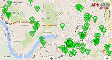
) Display real time nowcoast weather information and nexrad weather radar free access to more than 100.
000 seamlessly stitched usgs topographic maps easy to use as browsable map layer create and edit waypoints goto waypoint navigation create and edit routes (pro only!
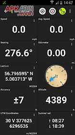
) Route navigation (point to point navigation) track recording (with speed elevation and accuracy profile) tripmaster with fields for odometer average speed bearing elevation etc.
Gpx kml kmz import export search (placenames pois streets) customizable datafields in map view and tripmaster (e.
G.
Speed distance compass...
) Share waypoints tracks or routes (via email dropbox facebook..
) Use coordinates in wgs84 utm or mgrs usng (military grid us national grid) get nws weather forecast track replay and many more...
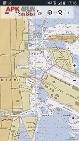
Available map layers: usgs drgs: seamless coverage of topo maps of the usa at scales 1: 250.
000 1: 100.
000 1: 6- 000 and 1: 2- 000 2- 000 usgs high resolution aerial imagery usgs national map orthoimagery for conterminous us google maps (satellite images road and terrain map) bing maps (satellite images road map) open street maps earth at night fstopo forest maps noaa nautical rnc charts public land ownership (padus) flight chartsavailable map overlays: hillshading overlay layer for osm google or bing maps (pro version only!
) Ridge weather radar nws wind te